Once your Companion has learned about other MeshCore stations, the Map gives you another way to understand some of the information available to you.
Instead of viewing stations only as entries in the Contacts list, the Map can display the locations associated with MeshCore nodes and let you explore them geographically.
This can help you understand where stations are located relative to you and to one another. But there is an important limitation to understand from the beginning:
Seeing a station on the Map does not necessarily mean your Companion can communicate with that station directly.
The Map shows location information. It should not be interpreted as a display of direct radio coverage or guaranteed connectivity.
Using the Map
Open the Map in the MeshCore app to see MeshCore nodes for which location information is available.
Depending on the information your Companion has learned, you may see markers representing different types of nodes on the map.
The Map can help you:
- See the approximate geographic location associated with a node.
- Recognize stations located around your area.
- Compare the locations of different MeshCore nodes.
- Select a node to view additional information about it.
- Relate what you see geographically to stations you have encountered elsewhere in the app.
Not Every Contact Appears on the Map
A station must have usable location information before it can be positioned geographically.
For that reason, a station can appear in your Contacts list without appearing on the Map.
This does not mean anything is wrong with the Contact or that the station cannot communicate through MeshCore. It simply means the app does not have the location information needed to place that station on the map.
Likewise, the number of markers visible on the Map should not be interpreted as the total number of MeshCore stations your Companion knows about.
Contacts tell you about stations your Companion has learned about. The Map shows the geographic information available for stations that can be placed on it.
Understanding What You See on the Map
The Map uses markers to show the geographic locations associated with MeshCore nodes.
As you move around the map, you may see nodes spread across your local area or farther away. Their positions can help you develop a geographic picture of where MeshCore activity exists, but the markers should not be interpreted as radio-coverage indicators.
A node appearing close to you on the Map does not guarantee that your Companion can hear it directly. Likewise, a more distant node may still be reachable through one or more repeaters.
The Map shows where a node is located. Paths and hop information tell you more about how that node may be reached through the mesh.
Selecting a Node
Tap a node marker on the Map to examine the information available for that station.
Depending on the node and the information available to the app, you may be able to see identifying details such as its name or other information associated with the station.
This makes the Map useful for connecting two different views of the network:
Contacts help you identify stations your Companion has learned about.
Map markers help you understand where stations with available location information are geographically located.
As you become familiar with the mesh around you, you may begin recognizing the same station names in both places.
Location Does Not Mean Direct Radio Range
This distinction is important enough to emphasize.
A Map is a geographic view, not an RF coverage map.
Terrain, antenna height, buildings, vegetation, radio conditions, and other factors affect whether two stations can communicate directly. Distance alone does not determine radio connectivity.
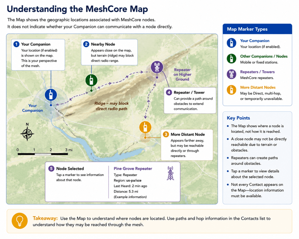
For example, a station several miles away on an elevated site might have an excellent direct radio path to your Companion, while a much closer station located behind a ridge may not.
Repeaters can also allow communication between stations that cannot hear each other directly.
Do not use the distance between two Map markers as proof that those stations can—or cannot—communicate directly.
Illustration point
I would stop there.
This is now the right place for the first illustration, titled:
Understanding the MeshCore Map
I recommend a map-oriented instructional graphic, not another phone workflow. It should show a simplified terrain/map view with:
- Your Companion at one location.
- A nearby node marker.
- A more distant node marker.
- A repeater/tower marker on elevated terrain.
- A ridge obstructing the apparent nearby path.
- A node selected with a small information card.
The key visual message should be:
Location shows where a node is. It does not show whether the radio path is Direct, multi-hop, or even currently available.
Understanding the Internet Map
MeshCore can also provide access to an Internet Map that gives you a broader view of MeshCore activity beyond what your own Companion has learned directly through the radio network.
This is an important distinction.
The regular Map is associated with information available through your Companion and the MeshCore app.
The Internet Map uses information collected and shared through Internet-connected MeshCore infrastructure and mapping services. Because of this, it may display stations and network activity far beyond the portion of the mesh known to your own Companion.
You may therefore see MeshCore nodes hundreds or even thousands of miles away.
Internet Map Does Not Mean Radio Reachability
Seeing a station on the Internet Map does not mean your Companion knows about that station or has a radio path to it.
The station may have been reported to the Internet mapping system by another observer, gateway, or participating MeshCore device elsewhere in the network.
This means two very different things are being shown:
Your Companion’s information reflects what your radio has learned about the mesh from its own position in the network.
Internet Map information can reflect observations collected from many different locations and shared through the Internet.
A node appearing on the Internet Map therefore should never be interpreted by itself as evidence that you can communicate with that node over MeshCore radio.
Map vs. Internet Map
The distinction can be summarized simply:
Map: Helps you geographically understand nodes represented by information available to your Companion and app.
Internet Map: Provides a broader Internet-assisted view of MeshCore nodes and activity reported from many locations.
Both can be useful, but they answer different questions.
The Map helps you understand your Companion’s view of the mesh around you.
The Internet Map helps you explore a much larger view of MeshCore activity beyond your own radio perspective.
Key Point: A station visible on an Internet Map may exist far outside anything your Companion can currently hear or reach through the radio mesh.

What the Map Can—and Cannot—Tell You
The map can be a useful way to understand the MeshCore activity around you, but it is important to interpret it correctly.
Seeing a station or repeater on the map does not necessarily mean your Companion can currently communicate with it. The map may contain information collected by other MeshCore stations and observers and then reported through the Internet.
Likewise, a station that your Companion knows about may not immediately appear on an Internet-based map. What you see depends on what information has been received and reported by the systems contributing to that map.
For a new user, the simplest distinction to remember is:
Your Companion shows you the mesh from the perspective of your own radio.
An Internet map can show you a much broader picture assembled from information reported by many radios.
This makes Internet maps particularly useful for exploring the larger MeshCore network, seeing where repeaters and other stations have been observed, and developing a better understanding of how the mesh extends beyond your immediate area.
Do Not Treat the Map as a Coverage Map
It can be tempting to look at stations on a map and assume that everything between them represents reliable radio coverage. That is not necessarily the case.
LoRa communication is affected by terrain, antenna height, buildings, vegetation, interference, radio configuration, and many other factors. Two stations that appear relatively close together on a map may not communicate directly, while stations much farther apart may communicate successfully because of favorable locations or repeaters between them.
The map therefore provides information about the network—not a guarantee of radio coverage or message delivery.
As you gain experience with MeshCore, the map becomes a valuable tool for understanding the network around you. For now, use it primarily as another way of seeing the stations and infrastructure that make up the larger mesh.
What You Should Pay Attention to First
At this stage, you do not need to understand every symbol, line, or piece of information that may appear in the MeshCore app.
Instead, concentrate on a few basic observations.
As you use your Companion, notice:
- Which Contacts appear and whether they are shown as direct or several hops away.
- Whether paths change over time as your Companion learns more about the mesh.
- Which repeaters appear to be involved in reaching other stations.
- Whether Direct Messages are delivered, remembering that a known path does not guarantee delivery.
- How the Map relates to what you see in Contacts, while remembering that an Internet map may contain information gathered by many other stations.
You are beginning to see MeshCore as a changing radio network rather than a fixed list of devices.
A station may appear, disappear, become reachable through a different path, or change from several hops away to a shorter path. None of those changes necessarily indicates a problem. They are part of the way a mesh network adapts as conditions and available stations change.
The Important Idea
You do not need to memorize everything the app displays.
For now, remember this:
Your Companion listens to the mesh, learns about other stations and possible paths, and presents what it currently knows through the MeshCore app.
Once that concept is clear, many of the details you encounter later—repeaters, paths, hop counts, routing, and changing network conditions—become much easier to understand.
What You Have Learned
You now have a better foundation for understanding the information your Companion and the MeshCore app show you as you use the network.
You have learned that:
- Your phone and Companion perform different jobs. The phone provides the app interface, while the Companion communicates over the LoRa radio network.
- The Contacts list represents stations your Companion has learned about, not simply stations it can hear directly.
- A Contact may be directly reachable or reached through one or more repeaters.
- Contacts, paths, and hop counts can change as your Companion receives new information and network conditions change.
- Repeaters extend communication through the mesh and can allow stations beyond direct radio range to communicate.
- Path and hop information describe how a station may be reached, rather than guaranteeing that every message will be delivered.
- The Map in the app and an Internet-based MeshCore map serve different purposes and may not show exactly the same information.
- A map showing stations and repeaters should not automatically be interpreted as a radio coverage map.
Most importantly, you now know that the information displayed in the app is not a fixed picture of the entire MeshCore network.
It is a view of the mesh based on what your Companion currently knows.
As your Companion continues listening and communicating, that view can change—and those changes are a normal part of operating on a mesh network.
Before Moving On
Spend some time watching the information in your own MeshCore app.
Open your Contacts list occasionally and notice which stations appear. Look at their hop information. Compare what your Companion shows with the Map, and watch for changes over time.
You do not need to diagnose those changes yet.
Simply becoming familiar with what a normal, changing mesh looks like will make the more advanced concepts in the following lessons much easier to understand.
Next Lesson
Now that you understand how the Map and Internet Map provide different views of MeshCore activity, the next step is learning how to use some of the tools available in the MeshCore app to examine the network more closely.
In the next lesson, we will explore tools that can help you investigate paths, discover nearby nodes, and better understand what is happening on the mesh.
Continue to: Using the MeshCore Tools →

